
Elterwater
Elterwater is a small village between Grasmere and Ambleside in Cumbria. The village is surrounded by stunning landscapes that make this an ideal location for photographers, offering a mix of mountains, rivers, woodlands, lakes and tarns.
My visit was to include a 6 mile circular walk from the village taking in Elterwater lake, Skelwith Force and Colwith Force waterfalls and the iconic Slater Bridge (shown in the main image).
The walk starts at the National Trust carpark in Elterwater village. While the car park is a reasonable size it does fill up quite quickly so it is worth getting there early. There is no other parking in the village itself but there are a number of locations on the access roads where you can park. These do fill up quickly again and tend to be occupied for long periods so parking can be tricky.
From the National Trust car park join the path through the gate behind the pay and display meter. This path, part of the Cumbria Way, takes you along the side of Great Langdale Beck towards Elterwater lake. All along the path there are stunning views of the surrounding fells including the rugged peaks of the Langdale Pikes.

Elterwater with the rugged Langdale Pikes in the background

Belted Galloway cattle in field near Elterwater
The path continues across open fields past Elterwater. There are often Belted Galloway cattle in the field that offer photographic opportunities. They seem oblivious to the people walking past but as always you should keep dogs on leads and avoid getting between cows and calfs during the calving season.
You then reach a wooded area and pass through a gate. Soon after the gate there is a bridge across the River Brathay - we pass by this bridge for now but will come back to it shortly. Continue along the path and you come to Skelwith Force. A narrow stepped path leads down to a viewing platform within the falls. The path is quite steep and can be slippery, particularly on the narrow metal bridges provided to reach the rocks.
The falls aren’t particularly tall, but there is a significant volume of water passing over them especially following periods of high rainfall. You can however get quite close so they do appear impressive.

Skelwith Force on the River Brathay

Access to the falls is via a narrow path and two small metal bridges
After Skelwith Force, return along the path back to the bridge we passed earlier. Now we cross the bridge and follow the track up into the woods towards Colwith Bridge. Once out of the woods you can see the main A593 road to your left. Continue along the path through the open countryside, offering stunning views across to the Langdale Pikes and surrounding fells.

After a while you arrive at Park Farm, pass through the gate and farmyard, following the track immediately to the left of the last building and follow the gravel track to pass over the two stiles. Pass through the gate cross the road and pass through the metal kissing gate to continue on the path towards the wooden area. As you enter the wood the path becomes narrow and heads down some steep steps towards the river. This leads you to a stile and gate built within the wall - turn right and follow the road for about 50m until you see some steps on the left, signposted for High Park and Colwith Force. Take the right hand path until you reach some stone steps - go right past the steps to reach Colwith Force.
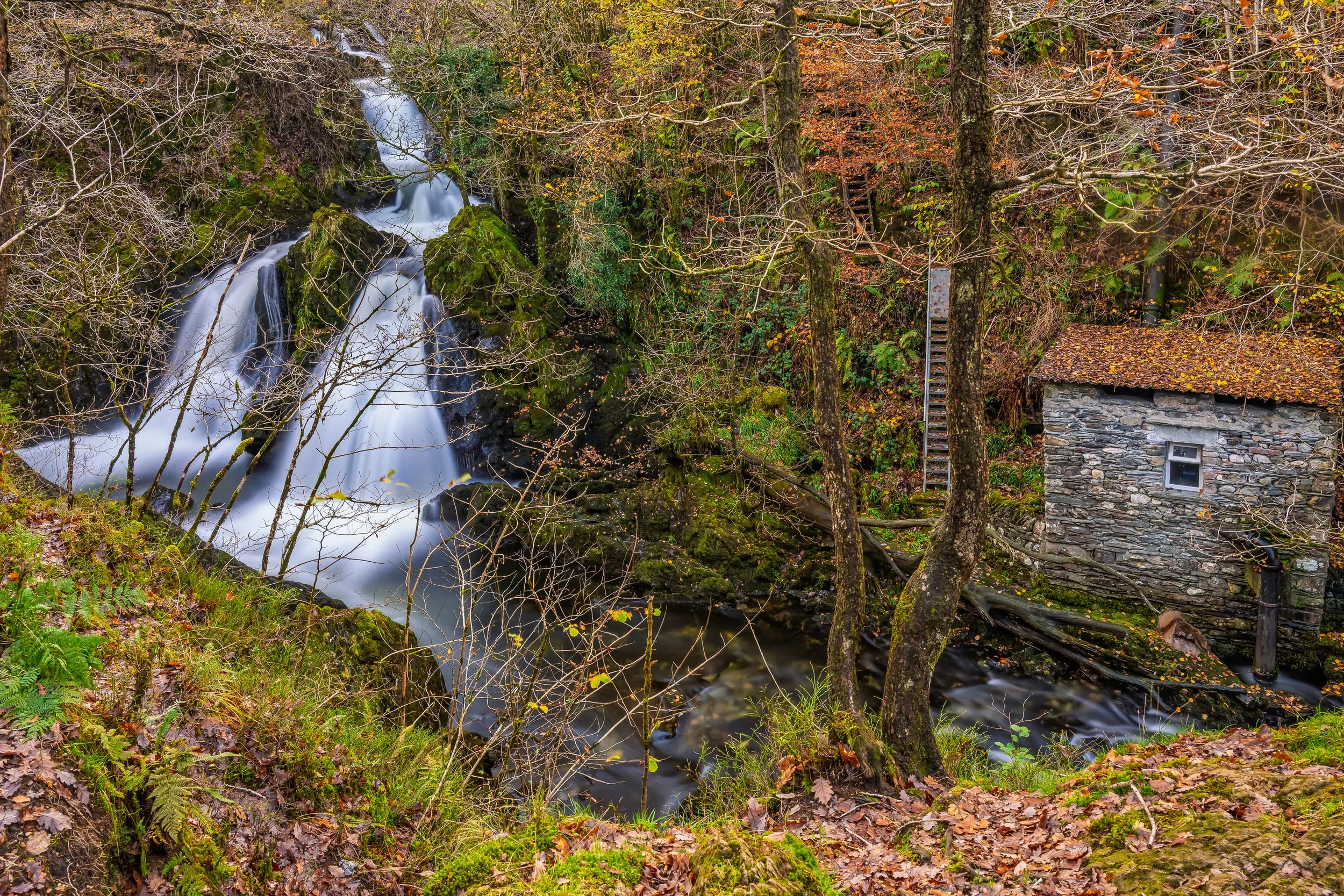
Colwith Force and Hydroelectric Plant
Colwith Force is a series of smaller cascades with the River Brathay falling around 15m (55ft). There is also a small stone building with access ladders on the far side of the falls. This building contains a small hydroelectric plant, taking water from above the falls through a pipe to drive a turbine before being returned to the river downstream of the falls. Autumn provides a better view of the falls once the trees have lost some of their leaves.
Return to the steps and climb up through the trees. Along the path you will find a Wish Tree, a fallen tree trunk with coins pressed into it. The idea of wishing trees dates back many hundreds on years when it was believed pressing a coin into the tree would grant a wish to cure illness. Follow the path as it continues to climb through the trees towards High Park Farm. The farm dates back to 1620 and was once owned by Beatrix Potter. There is a small tea room here for refreshments before continuing on.

High Park Farm in Little Langdale, a Grade II Listed farmhouse once owned by Beatrix Potter
Continue through the small gate to the right of the cattle grid and turn right onto the narrow road, passing by the sign pointing towards Coniston, and continue along the road downhill paste the farm buildings until the road becomes a gravel track at Tilberthwaite and meets up again with the River Brathay at a ford and small wooden bridge. Continue past the bridge and follow the path upstream. Pass through the wooden gate and over towards the right you should see Slater Bridge. Continue on the path for a further 50m or so until you reach a wooden kissing gate on the right. Go though the gate and follow the path to the stone wall. Just before you reach the wall you will see the classic photo of the bridge with Lingmoor Fell in the background.
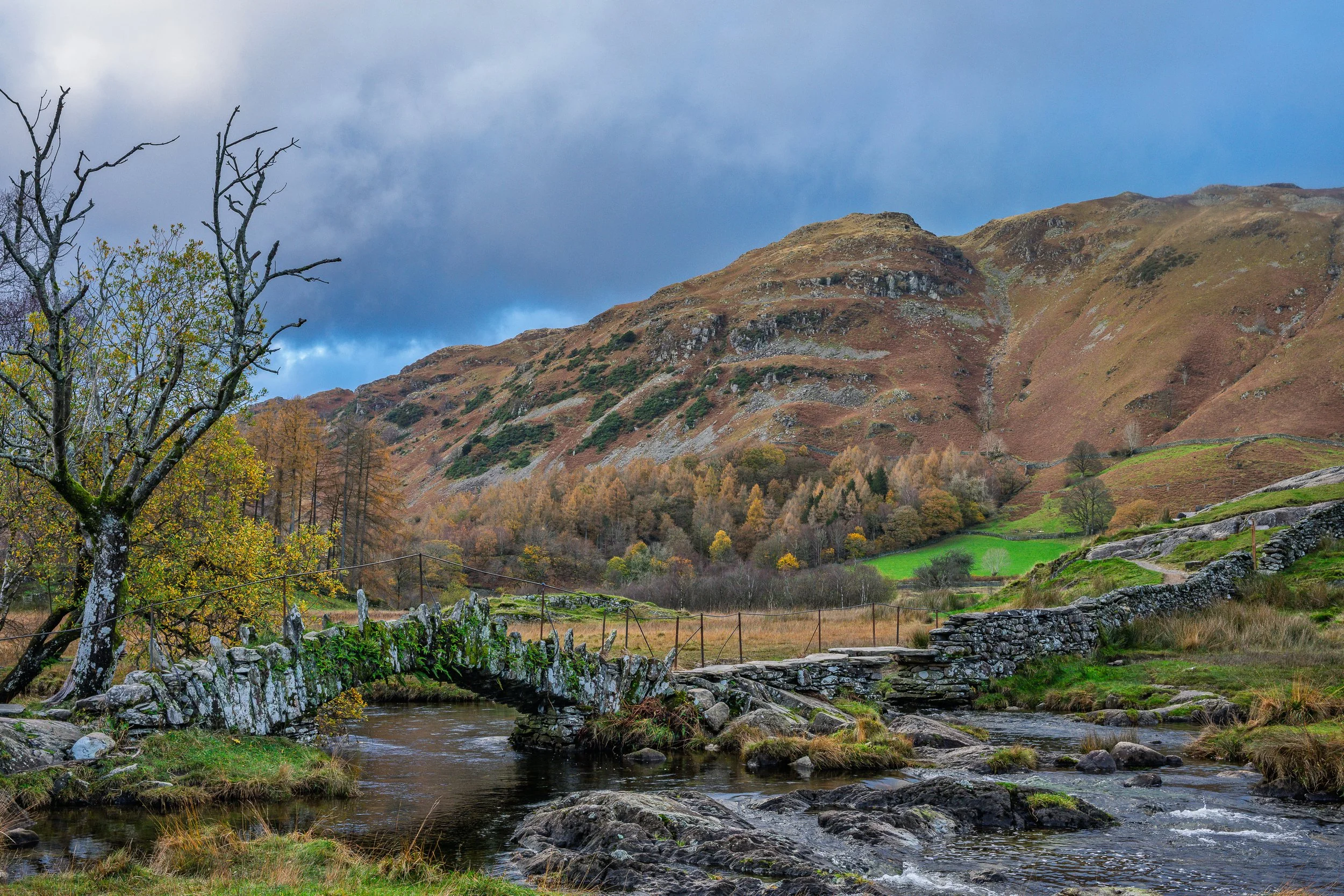
The classic view of Slater Bridge in Little Langdale with Lingmoor Fell in the background

Follow the path up to the left of the dry stone wall
Pass over the steps and stile in the wall to reach the bridge.
Slater Bridge is a traditional packhorse bridge over the River Brathay. It was built in the 17th century and is actually two separate spans built onto a large boulder in the middle of the stream. The first span is a 5m segmental arch made with local slate stones, combined with a second span built of flat slabs of slate. It is thought to have been constructed by slate miners from the nearby slate quarried.
Cross the Bridge and follow the path up to the left of the dry stone wall. (The path to the right of the wall takes you to the Three Shires Inn). The path climbs quite steeply at first but then levels off to provide views over Little Langdale Tarn.

Little Langdale Tarn

The highest point of the walk, just above Dale End before the track descends into Elterwater. The sun was starting to set as I was nearing the end of the walk.
Continue on the track up the hill and across the farmland until you reach the road. Turn left (turning right takes you to the Three Shires Inn) and then after a few metres turn right up the road marked “Unsuitable for motor vehicles”. Continue up the road towards the right of Lingmoor Fell. After a short while you come across an honesty parking area which can be used if you wish to start from a different location or only visit Slater Bridge.
Just past the rear of the white farm house at Dale End the road turns back into a gravel track and continues to climb up the fell for a short while before turning into a rock strewn path descending back into Elterwater. This path can be quite wet with surface run off following rain. It is quite a steep descent and seems to go on for quite a while so becomes very tiring on the legs.
At the bottom of the track we join the road at a signpost for the Elterwater Inn (to the right). Instead, turn left and continue down the road and cross the bridge over Great Langdale Beck to return to the National Trust car park.
The walk is considered to be of Moderate difficulty but I'm not too fit and found the two ascents (from Colwith Force to High Park and from Slater Bridge to Dale End) to be particularly strenuous and tiring. the majority of the walk though is fairly flat and easier to negotiate.

Walking Route from Elterwater village via Skelwith Force, Colwith Force and Slater Bridge
Getting There:
From Ambleside, take the A593 towards Skelwith Bridge and then continue on the A593 until you reach the B5343 signposted for Elterwater village. Follow the road into the village and the National Trust car park is on the left just before you reach the bridge over Great Langdale Beck.
There is also a bus service from Ambleside to Elterwater, leaving Ambleside’s Bus Interchange and arriving at the Britannia Inn in Elterwater, just opposite the NT car park. Journey time is approximately 18 minutes.
Elterwater National Trust car park Grid Ref: NY 327 047